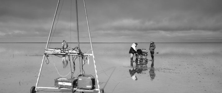
Since spring this year, FIELAX performs TRT measurements in tidal seas down to 6m below sea floor. The picture shows the installation of a 3,5m sensor string. The whole equipment can be transported 'per pedes' through the Wadden Sea.
Since spring this year, FIELAX performs TRT measurements in tidal seas down to 6m below sea floor. The picture shows the installation of a 3,5m sensor string. The whole equipment can be transported 'per pedes' through the Wadden Sea.

We kindly inivite you to visit us at the Oceanology International China, Asia’s largest exhibition for marine technology, in Qingdao (China) from 23rd to 25th October 2018. Visit our booth F13 and learn about our geothermal heat flow services, temperature models and intruments!
Link to OI China official website
FIELAX’s attendance at the OI is financially supported by the EFRE (European Fund for Regional Development).
Within a feasibility study FIELAX GmbH analysed the soft- and hardware technical implementation of a digital, INtelligent underwater interpretation and communication assistant (INKA) and described all necessary steps for the further development. There are several practical examples of applications which would improve technically as well as economically.
This project was supported financially by the federal state of Bremen.
We kindly invite you to visit us at Oceanology International, one of the largest exhibition for marine technology, in London from 13th to 15th March 2018. Visit our booth F200 and learn about our geothermal heat flow services, temperature models, software development offerings and instruments.
We are excited to meet you there!
Link to OI International official website
FIELAX's attendance at the OI is financially supported by the EFRE (European Fund for Regional Development).

Our (from now on) exclusive representative in China 青岛国科 (QDGK, Qingdao GuoKe) and us had a great show last week in 青岛 (Qingdao, China). We built new business contacts, developed new ideas and brought a lot of positive impressions. Read more